Every hike is a little bit different. Some have panoramic views of mountains, lakes, and valleys. Others offer the serenity and isolation from everyday civilization. For this one, just let the pictures do the talking...
Date: Saturday, September 8, 2007
Destination: Mt. Defiance summit, 5,584 ft, highest point in Columbia Gorge
We began our day at the Starvation Creek trailhead, which sits neatly alongside Interstate 84 about an hour east of Portland. Our goal was to hike up the Mt. Defiance Trail to the summit, then return via Warren Lake and the Starvation Creek trail.
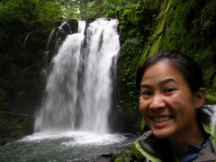
The trail began by backtracking and following the interstate for about 1/4 mile to an area anchored by several beautiful waterfalls. According to my hiking book, Hole-in-the-Wall Falls (see on left) was created when ODOT diverted Warren Creek through a tunnel in an adjacent cliff. There's also a cool little tree shaped like a wishbone that is quite fun to sit on and take silly pictures.

About 1/2 mile further along the Mt Defiance trail is Lancaster Falls, which actually runs into the trail's path. Its fan-like shape reminded me of Sahalie Falls along the McKenzie Highway, but with less greenery. While I was attempting to take a photo, an excited dog ran up the trail and startled me! Not too far past this pretty little stretch of waterfalls, the trail steepens as it climbs the ridge along the Columbia Gorge. Views of the river below were pretty awesome on this clear day.
 After about 2.5 miles of unrelenting switchbacks, a short spur from the trail leads to a small viewpoint. I am not sure what the peak is immediately across the river, but it provided for some great shots. If you look carefully, Mt St. Helens can be seen in the distance. Switchbacks continue for 2 miles or so up the ridge before emerging onto the shoulder of a talus slope. From left to right, views here include Mt St. Helens, a distant Mt Rainier, and a slightly obscured view of Mt Adams. It was a nice change from the dense forest earlier.
Falls colors were already settling in as we passed a huge talus field about 1 mile from the summit (less than 1/4 mile before the summit trail cutoff). The microwave towers on the summit were clearly visible from this point. Here, the Gorge view extended from Hood River to The Dalles in the east.
 Somewhat anti-climatic, the summit was anchored by a couple of small utility buildings, microwave towers, and some unsightly backhoes and port-o-potties. What a terrible way for a first time view! There is also a dirt road here from somewhere down below for those who want the view, but not the work. We walked around to the southeast side of the summit and was captivated by the panoramic views of Mt Hood and the valley below. Like many other places in Oregon, golden mantle ground squirrels ran amok begging for food from hikers. We posed for summit pictures and refueled on my sister's yummy peanut butter sandwiches before beginning our descent.
 We chose an alternate route from the summit that took us around the west side for an overview of Bear Lake. Lots of talus crossings here, but very level and easily followed. Back on the main trailhead we went toward Warren Lake, a little slice of heaven on the shoulder of Mt Defiance. The shores are dotted with several cozy campsites. Although we didn't see any actual fish in the lake, the made their presence known with occasional water bubbles here and there.
We took the Starvation Ridge trail for the return trip to the trailhead.  The scenery was quite different from the Mt Defiance trail along the other ridge. The forest floor here were much more open and the ground covering much greener from the additional sunshine. About 1.5 mile from the trailhead, around 7:30pm, dusk began to set in, gradually dimming what light there was on the forest floor. The ridge was a bit steep and slippery in places. Luckily, I had brought my trusty headlamp to guide us down the ridge. I would trek ahead of my sis and bro-in-law a few yards, then shine my headlamp back along the trail so that they can follow suit.
 The scenery was quite different from the Mt Defiance trail along the other ridge. The forest floor here were much more open and the ground covering much greener from the additional sunshine. About 1.5 mile from the trailhead, around 7:30pm, dusk began to set in, gradually dimming what light there was on the forest floor. The ridge was a bit steep and slippery in places. Luckily, I had brought my trusty headlamp to guide us down the ridge. I would trek ahead of my sis and bro-in-law a few yards, then shine my headlamp back along the trail so that they can follow suit.
 Just before the final series of switchbacks began, we reached an exposed viewpoint that overlooked the Columbia River and the interstate below. The night view was beautiful. I'll bet it is even better and more dramatic than the daylight view. Around 8:30pm, we descended onto flat ground for the main trailhead.